Some vintage pictures from the Providence Journal files of the tunnel under Lovecraft’s College Hill…


06 Monday Oct 2014
Posted in Historical context, Maps
Some vintage pictures from the Providence Journal files of the tunnel under Lovecraft’s College Hill…
25 Thursday Sep 2014
Posted in Historical context, Maps
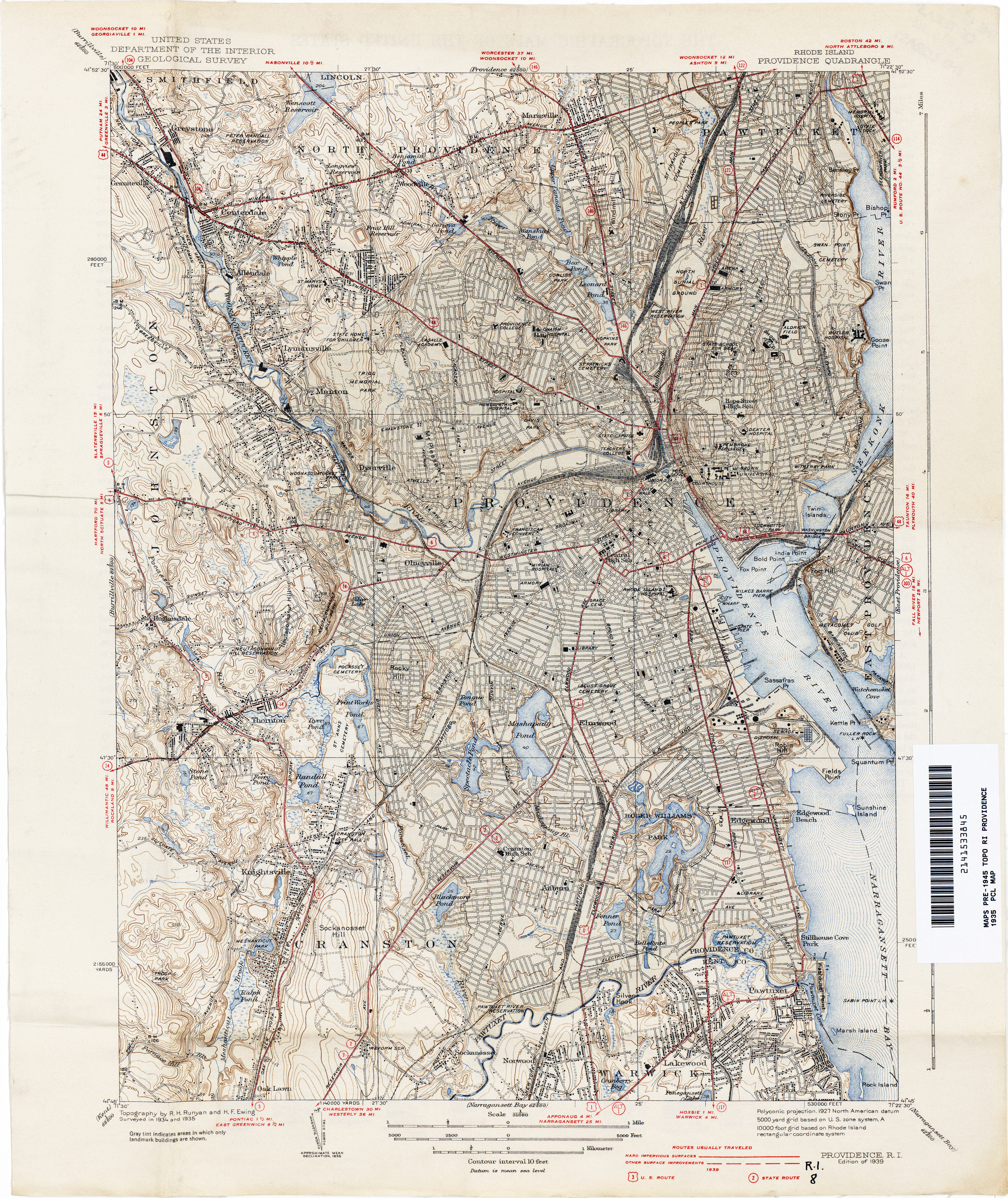
Large scan of a large-scale USGS topographical map of Providence, 1935, courtesy of the University of Texas.

26 Tuesday Aug 2014
Posted in Historical context, Maps
Tharp and Heezen’s mid-1950s “The Floor of the Oceans” map, in hi-res. Just in case Mythos writers needed to research a location for an underwater city or something.
Note especially the curious shape of Greenland. Presumably envisaged that way to show the sub-glacial meltwater lake area, possibly with life, which lies deep beneath the now-thickening ice cap (the thickening is why more ice is falling off some of the edges, since the weight of the inner mass pushes it off).

In Lovecraft’s day the ocean depths were mysterious unmapped places, plumbed primarily by submariners and those laying undersea telegraph cables. The weirder denizens of the deep were better known, having been hauled up by the likes of the Challenger Expedition and also by occasional startled fishermen. And hunted by the likes of the Arcturus Expedition. The bathysphere (metal diving sphere) was essentially still just an interesting one-off novelty in the mid 1930s. The first modern textbook on oceanography was not published until 1942, after Lovecraft’s death. Only after the Second World War — with war-surplus Navy ships and sonar at the disposal of scientists — could sea-bed mapping be undertaken in detail and over wide areas.
18 Wednesday Jun 2014
Posted in Historical context, Maps, New discoveries
“168 Lonely bleak islands off N.E. [New England] coast. Horrors they harbour—outpost of cosmic influences. (H.P. Lovecraft, story idea #168 in the “Commonplace Book”)
“There was a lone southward-sailing ship, and far out the eye could barely discern the misty suggestion of the half-fabulous Isles of Shoals [four miles off the coast from Portsmouth]. I had not seen the ocean before for six years—the glimpses one gets in harbours are nothing.” (H.P. Lovecraft, June 1922, Selected Letters I, p.185.)
“the low, black reef lay a full mile and a half out from Innsmouth Harbour.” … “Far out beyond the breakwater was the dim, dark line of Devil Reef, and as I glimpsed it I could not help thinking of all the hideous legends I had heard in the last twenty-four hours—legends which portrayed this ragged rock as a veritable gateway to realms of unfathomed horror and inconceivable abnormality.” (H.P. Lovecraft, “The Shadow Out of Innsmouth”)
Lovecraft had visited Portsmouth just one month before writing “The Shadow over Innsmouth”.
“They are supposed to have been so called, not because the ragged reefs run out beneath the water in all directions, ready to wreck and destroy, but because of the “shoaling,” or “schooling,” of fish about them, which, in the mackerel and herring seasons, is remarkable.” (Atlantic Monthly, 1869)
“the abundance of fish was certainly almost uncanny” … “Queer how fish are always thick off Innsmouth Harbour” (H.P. Lovecraft, “The Shadow out of Innsmouth”)
“As he [‘King’ Haley] turned over a stone one day [on his Haley Island, part of the ‘Isles of Shoals’] he found three bars of solid silver [and with that mysterious treasure built a sea-wall and a wharf]” (real-life story in “The Isles of Shoals”, Harper’s Weekly)
“always been a kind of mystery where the Marshes get the gold they refine … Others thought and still think he’d found an old pirate cache out on Devil Reef” (H.P. Lovecraft, “The Shadow out of Innsmouth”)
Of course Lovecraft probably never visited those particularly barren and low-lying Isles, only spied them from the coast and read of them. A visit entailed a full day-trip on a steamer from Portsmouth in the 1920s. The steamer landed passengers at the main Star Island, where the Oceanic Hotel was a church-run establishment and any cafes likely served quite expensive refreshments to a captive audience of trippers. So it’s more likely he just read up on them, then imagined that the most bleak of the Isles — such as the barren northern Duck Island and its ragged reefs and ledges — might be transplanted elsewhere, and brought closer in so that it would be clearly visible from a hideous old town.

 Above: ‘The Isles of Shoals’ seen in relation to Portsmouth, 1917 topographic map. The map’s marking of “Town of Kittery” and “Town of Rye” across the islands indicates legal jurisdiction, not that the islands had towns on them. The hotel on Appledore island had burned down in 1914.
Curiously, given the supposedly ‘ever-rising sea levels’ that are supposed to soon inundate the nearby New York City, global warming has left completely untouched the coastline of these lowest of low-lying islands.
18 Wednesday Jun 2014
Posted in Historical context, Maps
[Update: I later had an additional post on the Newburyport shoreline].
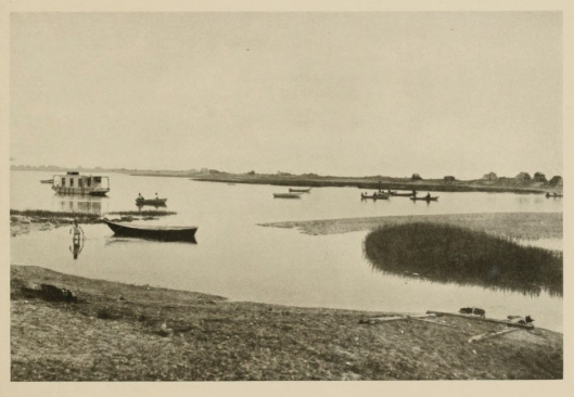
Old Newburyport, giving impressions of how H.P. Lovecraft might have seen it.


Newburyport harbour in the 1850s, painted by Richard Burke Jones with historically accurate details. Prints available.

The waterfront district circa 1920.
 More waterfront, from a lower elevation, view of the bridge.
 Bridge at Newburyport.
 As a working port.

Coal conveyors, presumably to fuel up the steamships.
 Light tower at Newburyport, coal conveyor to the steam ships.
 Train station. Lovecraft may have instead arrived by trolley in most instances (see David Goudsward, H.P. Lovecraft in the Merrimack Valley), but perhaps the train station and cross-country trolley terminus were the same place? He probably passed through on this line on his return south after visiting Portsmouth in the early 1930s. He also probably arrived here on the train from/to Boston at least once.
 Commercial centre.
 Commercial centre.
 Commercial centre.
 Trolley car out of the market square.
 Joppa Landing (past the main commercial centre, Lovecraft missed the centre and went hurtling on into this area on the trolley, then walked back).
 Clam shacks at Joppa Flats. The trolley car lines have been painted out, but you can see the trolley wire posts.
 Clam pickers on the flats.
 Salt-haying on the adjacent marshland. Seen in October from the train line that crossed the marshlands, when Lovecraft was returning south from a visit to Portsmouth, could these have looked like shoggoths-in-the-mist? 🙂
 Salt-haying on the adjacent marshland.
 Newburyport waterfront partially cleared in the early 1970s, just before restoration.
 Newburyport waterfront partially cleared in the early 1970s, just before restoration.
Many more excellent old photos at The Newburyport blog of Mary Baker Design.
17 Tuesday Jun 2014
Posted in Historical context, Maps, New books
Book Review:
David Goudsward, H.P. Lovecraft in the Merrimack Valley, Hippocampus Press, summer 2013. $15 print-on-demand paperback, 192 pages. Foreword by Kenneth W. Faig. Jr., with an afterword by Chris Perridas. Illustrated, basic index. The book was read completely and carefully.

David Goudsward is obviously a prodigious walker, just as H.P. Lovecraft was. One has to marvel at the amount of physical legwork and boot leather that went to make this new book. Goudsward has walked and ridden every one of the various routes that Lovecraft threaded through the Merrimack Valley, and he has also wandered through what remains of the antiquated foot-ways of its eastern fishing towns. At the end of the book he even provides readers with a useful short gazetteer, listing places he has visited and which are currently open to the public. For those who can’t make such visits the book offers abundant and crisply reproduced black-and-white pictures. These pictures are either Goudsward’s own, or those he has ably sourced from local archives.
The book is well organised, and the text and pictures flow well together. But much tedious and time-consuming page-flipping might have been avoided by having the footnotes placed at the bottom of each page, instead of at the back of the book. It would also have been useful to have had at least one map of the area, but there are none. This seems a pity, when there are excellent old maps in the public domain at high resolution…
 Above: Newburyport in 1888, topographic map. Full version.
Of course the more digitally adept reader might juggle a digital tablet with the book, and thus ‘follow along’ via the wonderful Google Maps and Google Street View (a free tool which now allows researchers to scout out Lovecraft’s locations from the comfort of their PC). Sadly the modern Haverhill — the setting for the first half of this book — doesn’t lend itself to such Googly goodness: Goudsward informs the reader that the centre of Haverhill was effectively destroyed by the urban-planning vandals of the 1960s and 70s.
 Above: Haverhill in 1888, topographic map.
The book opens with a short but engaging foreword by the veteran Lovecraft researcher Kenneth W. Faig, Jr. Faig immediately grabs the Lovecraftian reader by the lapels, with a stirring call to undertake the daunting task of making a complete day-by-day summary time-line of Lovecraft’s life, in the same manner as has already been done for Abraham Lincoln. That might best be done alongside an online searchable edition of the complete corpus of surviving letters (with only fragments shown, as with Google Books, in order to prevent piracy). In the meantime, books such as H.P. Lovecraft in the Merrimack Valley can help to fill some of the gaps, in terms of an almost day-to-day documentation of Lovecraft in one particular place.
Goudsward more or less strides through the events chronologically, with only a few sharp switchbacks into town histories. He opens with a succinct but detailed account of the life of Lovecraft’s fellow amateur pressman Charles W. “Tryout” Smith (1852-1948) of Haverhill. In the book’s appendices “Tryout”, along with Myrta Alice Little, is treated to a fine and painstaking listing of all solo publications.
Then the reader is stepped through the story of Lovecraft’s initial 1921 stay-over meeting with a near neighbour of “Tryout”. This person was the very tall, very beautiful and very intelligent Myrta Alice Little (1888-1967). Lovecraft was perhaps not ‘on top form’ when he met her, being only a few weeks into mourning for his dead mother. Myrta fairly soon decided to marry a local Methodist preacher, and Lovecraft was rather left in the dust. I was surprised to discover that “Tryout” Smith also swiftly departed the Haverhill scene, albeit in a very different way — he became a total recluse at a place called Plaistow between 1922 and 1926, seemingly admitting no visitors at all. Not even Lovecraft.
But Lovecraft did retain a good reason to visit Haverhill, and to explore the area’s antiquities. From March 1922 he had cultivated a friendship with a bright thirteen year old boy named Edgar J. Davis (1908-1949) of Haverhill. Lovecraft befriended Edgar’s family and was allowed to stay over at his home. Together he and Edgar were allowed to go off on trips of local exploration. They eagerly visited the shadowy crumbling estuary-mouth seaport of Newburyport, later admitted by Lovecraft to be — in part — a model for the famous story “The Shadow over Innsmouth” (written Nov-Dec 1931). Here one of Goudsward’s claims about Newburyport made me pause. It was a small claim that the old Bayley Hat (Chase Shawmut) factory was the direct model for the Marsh Refinery of “Shadow Over Innsmouth” (p.47). I felt this claim needed more evidence. On the other hand, the place does look like a plausible candidate, seen here in an elevation sketch I found from circa 1903…

Like many of Lovecraft’s places, Innsmouth was very probably a bit of a literary collage. He probably borrowed elements from different places: a marshy shoreline from here; a familiar town grid plan from there; add a road by which to approach in an atmospheric manner; give it human pathos by using the crumbling elegant architecture and fishing shacks of Newburyport. Then top it off with a creepy reef way offshore; a horrible hotel; a mysterious refinery; and an old abandoned railroad, some of which were perhaps simply dreamed up from his abundant imagination to suit the needs of the plot.
Goudsward’s book also looks at Lovecraft’s later (post New York) trips to Newburyport and the region, in the company of W. Paul Cook. The bright young Edgar J. Davis had by that time grown up and gone off to Harvard to study law. In this section I again paused over just one of the claims made: that a coral reef Lovecraft saw on a Miami tourist trip was the direct inspiration for Innsmouth’s Devil Reef (p.70). Yet Lovecraft’s description of the jaunt (not given in the book) seems rather incongruously bright-and-sparkly for something so dark and brooding…
“… sailed out [from Miami] over a neighbouring coral reef in a glass-bottomed boat which allowed one to see the picturesque tropical marine fauna & flora of the ocean floor.” (Selected Letters III, p.380)
The northern third of the nearby ‘Isles of Shoals’, four miles offshore from nearby Portsmouth and ten miles NW of Newburyport, might have been a more plausible suggestion for the idea of the Reef. Although that’s not to say that Lovecraft ever visited any of the bleaker of those islands. While a couple of the larger islands had become minor tourist traps (Hawthorne wrote the junior HPL fave Tanglewood Tales there), most of ‘The Isles of Shoals’ is a sprawl of lonely low islands and tidal ledges just above the sea, where “ragged reefs run out beneath the water in all directions” (Among the Isles of Shoals, 1873). Lovecraft had visited Portsmouth just one month before writing “The Shadow over Innsmouth”.
Above: ‘The Isles of Shoals’ seen in relation to Portsmouth, 1917 topographic map.
I did wonder if more might have been said in the book about the historical as well as the geographical context. By historical context I mean the sweep and impact of large implacable forces, such as the shifts in the economy and the coming of modernity to the area in the 1920s. Goudsward does have some short town histories, and some paragraphs that try to say why Newburyport was decaying. But his bibliography lacks the sort of books that might have given him some useful big spotlights, with which to illuminate small details to do with Lovecraft. While pounding the same streets as Lovecraft did can obviously be very useful, an equal pounding on digital doors — of Google Books, HathiTrust, Archive.org, Library of Congress pre-1922 online newspapers, and suchlike — might have yielded Goudsward a few useful additions to his book. For instance, the drastic overfishing at Innsmouth and the town’s keen desire for vast new shoals of fish. Is something similar to be found in the history of the Merrimack River? At Google Books I swiftly found the interesting fact that…
“Fish were a critical link in the Merrimack valley’s food chain”, and that these fish were vastly overfished and the river over-dammed by commercial interests in the early 1800s, and the fish life of the river consequently suffered a severe ecological collapse in what had once been one of the finest salmon rivers in America. (For full details on this story see the chapter “Depleted Waters” in Nature Incorporated: Industrialization and the Waters of New England, Cambridge University Press, 2004.)
There seems an obvious parallel here with the depiction of the fictional collapse of the Innsmouth fishing economy…
“Most of the folks araound the taown took the hard times kind o’ sheep-like an’ resigned, but they was in bad shape because the fishin’ was peterin’ aout…” (Zadok in “Shadow over Innsmouth”)
“That fishing paid less and less as the price of the commodity fell and large-scale corporations offered competition… [but by then Innsmouth had the fish being herded in…]” (“Shadow over Innsmouth”)
I also wondered about a rhetoric around population ‘degeneration’ at the time, apparently specific to the region. I wondered how early this developed in 1921—1931, the period under discussion in the book, as evidenced by the local and regional newspapers…
“by the 1930s […] entire regions like north-eastern Connecticut and the Merrimack Valley of New Hampshire and Massachusetts appeared to be left behind by history, and the sight of abandoned factories was as common as that of deserted farms” […] “the rural hinterlands seemed to be largely populated with inbred, degenerated retards” [and newspapers pictured] “them as a bunch of mutated dwarfs, giants, and idiots.” (Bernd Steiner, “The Decline of a Region”, H.P. Lovecraft and the Literature of the Fantastic, 2007, p.33).
Finally, there is ‘Mystery Hill’. Goudsward has long been associated with the so-called megalithic site of ‘Mystery Hill’ in New England, and so I was rather dreading reading a gusher of an essay on the topic, but find that the essay is relegated to an appendix in the book. I am no expert on the New England megaliths controversy, other than to know to be highly sceptical of North America’s ubiquitous faux prehistory. But I was pleased to find what appears to be a restrained and rather careful look at the known evidence about Lovecraft having once visited this site. I only worried that I could find nary a whit nor a sniff of the name “Pattee’s Caves” (which Goudsward states was the old local name for ‘Mystery Hill’, before its mid 1930s purchase and transformation) in any of the big pre-1926 online archives. After sifting the dubious claims of Munn and others, Goudsward finally alights on an elegant and moderately plausible way to get Lovecraft up to ‘Mystery Hill’. I won’t spoil the surprise for readers, but it’s a fun ride getting there. Even if Goudsward is right on that point, then it still doesn’t prove that the highly dubious man-sized stone slab now in pride of place at ‘Mystery Hill’ was present and visible there in 1921. Nor that Lovecraft then recalled that same slab a few years later, and fictionally hoisted it atop Sentinel Hill in “The Dunwich Horror”.
Overall the book is an engaging read, and I recommend it to those who want the fine and thought-provoking details about the inspirations for Innsmouth and how Lovecraft came to know the Merrimack River area.
Contents:
Foreword, by Kenneth W. Faig, Jr.
Preface
Acknowledgements
H.P. Lovecraft in the Merrimack Valley
Transformations
First Visits: 1921
Whittierland and Newburyport
Intermezzo: 1924–1926
Innsmouth Ascendant: 1927–1931
Dreams and Eclipses: 1932–33
Shadows out of Haverhill: 1934–36
Coda
Appendices
The Haverhill Convention, by H.P. Lovecraft
First Impressions of Newburyport, by H.P. Lovecraft
Tryout’s Return to Haverhill
Plaistow, N.H., by C.W. Smith
The Return, by H.P. Lovecraft
The Published Works of Myrta Alice Little Davies
Howard Prescott Lovecraft, by C.W. Smith
The Publications of Charles W. Smith
H.P. Lovecraft, “The Dunwich Horror,” and Mystery Hill
Sites Open to the Public
Notes
Lovecraft: A Sense of Place and High Strangeness, by Chris Perridas
Bibliography
Index
05 Thursday Jun 2014
Posted in Maps, Scholarly works
Shannon Geis (2014), “Ambiguous Borders: exploring definitions of community in Red Hook, Brooklyn, an audio walking tour” (Masters dissertation for Columbia University, May 2014)

17 Friday Jan 2014
Posted in Historical context, Maps
03 Tuesday Sep 2013
Posted in Historical context, Maps
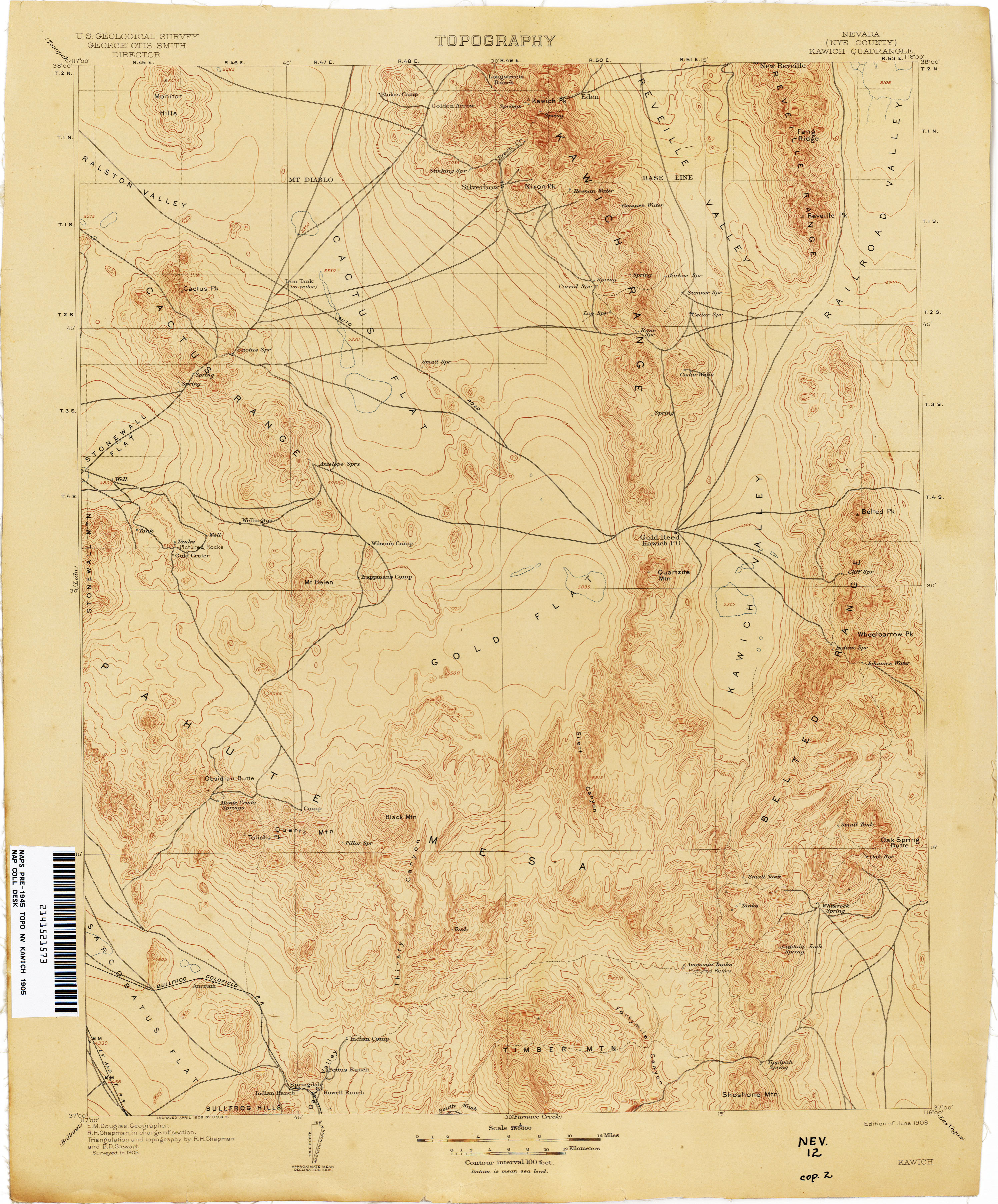
Lovecraft’s early failure “The Transition of Juan Romero” (Sept 1919) is located in “the Cactus Mountains”…
“In the summer and autumn of 1894 I dwelt in the drear expanses of the Cactus Mountains, employed as a common labourer at the celebrated Norton Mine, whose discovery by an aged prospector some years before had turned the surrounding region from a nearly unpeopled waste to a seething cauldron of sordid life.”
There really were and are “Cactus Mountains”, which lie south-east of Tonopah. Gold was first discovered there 1900, the gold rush there was 1903, and by 1915 the area south of Tonopah was the U.S.A.’s second biggest gold producing locality. The “Cactus Mountains” can be traced in documents from the 1840s, through to the following article in the Mining and Scientific Press magazine (1912). This article gives some of the history and details of a new 1911 gold discovery at the southern tip of the Cactus Mountains, Lovecraft’s exact setting…

There had also been new mines sunk at that spot by a British miner (recalling the nationality of the narrator of “Juan Romero”?), ostensibly for other minerals, back in 1908. The British miner’s name was Samuel G. Knott, and he was president of the Cactus Range Gold Mining company of Goldfield. His Mine Supervisor there was Elmer F. King. So far as my researches can tell, Knott was not known to have previously been in British India (as the British narrator of “Juan Romero” had been).
Mention of these mountains also occurs in a U.S. Navy report of 1977… “The 8 to 10 miles of blasting required along each antenna line occurs in the Cactus Mountains on the Tonopah Test Range…” The mountains are now better known as the Cactus Range (Lovecraft also uses this name in the story) and they form part of a vast highly-restricted military testing ground. The location in particular is now “Area 52, Tonopah Test Range“, sited 30 miles SE of Tonopah …
“lies mostly within the Cactus Flat valley, consisting of horst and graben geology. It is flanked by the Cactus Range hills to the west”
Yes, conspiracy fans, Lovecraft got there first as usual — this Area 52 is the neighbour of the fabled Area 51. 🙂 Which, for some, may bring a new frisson to the story’s descriptions — since they appear to somewhat prefigure the tropes of UFO folklore…
“[the mysterious sound from the newly-discovered bottomless cave] was like the pulsing of the engines far down in a great liner, as sensed from the deck, yet it was not so mechanical; not so devoid of the element of life and consciousness.”
“At first I beheld nothing [in the bottomless pit] but a seething blur of luminosity; but then shapes, all infinitely distant, began to detach themselves from the confusion, and I saw — was it Juan Romero? — but God! I dare not tell you what I saw!”
Another curious co-incidence is that the story “Juan Romero” was not published until 1944. I’m no expert on the history of UFOs, but that appears to be the same year as the UFO craze first started.
Lovecraft also sites the action in “Juan Romero” directly beneath a “Jewel Lake”. Sadly this name, like the name “Norton Mine”, doesn’t lead anywhere. The area is a volcanic plateau at 6,000 feet, and is very dry on the surface although there are springs and water not far down under the earth. According to the following 1905 topographic map there was no actual named lake at the exact spot, and the history book Preserving the Glory Days: Ghost Towns and Mining Camps of Nye County, Nevada has no mention of a Jewel Lake (or a Norton Mine, for that matter). Although the blue dotted areas on the 1905 topo map perhaps indicate there were temporary flashes of valley-bottom water in winter?

There is a huge “Mud Lake” nearby, though. So I wonder if Lovecraft may have flipped the meaning of the name, from Mud to Jewel?
How did Lovecraft come to know of the area? He appears to have been inspired in his choice of a desert setting by reading an amateur journalism author he named in a letter as ‘Phil Mac’ (Prof. Philip B. McDonald), who had apparently used a similar desert / mining setting, but for a “commonplace adventure yarn” (Lord of a Visible World, p.69). It seems Lovecraft had copied out a “dull” and “commonplace adventure yarn” sent to him by McDonald, intending to send the copy to his correspondence circle with a detailed critique of his own. But then he decided to just spend a day writing his own story based on the same or similar setting, and he then sent out both… “Youze gazinks have seen both Mac’s and my yarns.”
Philip B. McDonald graduated M.E. (Master of Engineering) from Michigan College of Mines. In Lovecraft’s The Conservative, McDonald was stated to be “Assistant Professor of Engineering English, University of Colorado” in July 1918, though he later moved to New York to become assistant professor of English, New York University. It appears he was the husband of the noted amateur journalist Edna Hyde McDonald (“Vondy”). McDonald’s desert story was not used in Lovecraft’s The Conservative and seems not to exist today, nor any of his fiction. So we don’t know how closely Lovecraft used, or not, what he called “the richly significant setting” of McDonald’s “dull yarn”.
02 Monday Sep 2013
Posted in Historical context, Maps
Stone Wings blog has walked and traced the route of the Lovecraft/Eddy Sunday 4th November 1923 expedition to find the notorious Dark Swamp in western Rhode Island, and reports with fine photographs. Dark Swamp was never actually reached by Lovecraft that day, although he and his “newly adoped son” C.M. Eddy hoped for another trip in summer 1924 that seemingly never happened…
“We now know how to reach the swamp most expeditiously, and will not again lose time in devious inquiries. It will be a pleasing day’s trip, and even tho’ we discover no unsuspected horror, we shall surely behold enough of the darkly picturesque to furnish out a dozen tales apiece.” (Selected Letters I, pp.264-67).
Their not reaching the swamp was probably just as well. Since it reputedly had many snakes, sump pools, and morasses, and was probably filled to brimming by the heavy October rains of that year.
Back in 2001 The Cthulhu Prayer Society (Newsletter, 11th Nov 2001) also followed the route of the walk to Dark Swamp. Jarett Kobek actually made it into part of the Dark Swamp and has online photos of White’s Pond and also part of the swamp.
The swamp had been penetrated by several naturalists early in the 20th century…
“Howard W. Preston, whose Botanical Notebook for the years 1877-1919 awaits and deserves publication, recorded his search for rhododendron in Dark Swamp, Glocester, Rhode Island by the Willie Woodhead Road.” (The Bulletin of the Massachusetts Audubon Society, 1966).
“As early as 1911, Fred Barnes served as a guide into the Dark Swamp in West Glocester for a research group from Brown University” (Glocester, the way up country: a history, guide and directory, 1976).
The swamp was/is not far from Chepachet, the north part of the road from Chepachet to Pascoag being of course the setting for the opening of Lovecraft’s “The Horror at Red Hook”. That was where Malone recoils in horror at reaching the junction and unexpectedly seeing buildings not unlike New York tenements in style. Such buildings can still be seen at that Pascoag junction, using Google StreetView, although they are on the right rather than the left turn. Lovecraft had been for another ramble in this area with Morton, a little earlier in 1923, in search of Durfee Hill (one miles east of the swamp, and Rhode Island’s second highest point), and so it’s possible he may have walked the same stretch of road that appears in “The Horror at Red Hook”.
According to S.T. Joshi’s I Am Providence, the visit to Dark Swamp was also recorded by Lovecraft in a letter to Edwin Baird. But I’m not sure where that’s been published, if it has been.
L. Sprague de Camp wrote in Lovecraft: A Biography that part of the Dark Swamp was submerged by the Ponaganset Reservoir a few years after the Lovecraft/Eddy trip — but judging by the modern satellite photography, trail maps, and the fact that Ponaganset Reservoir was completed in 1865, this cannot be correct.

Similarly shaky on certain points of fact may be Eddy’s recollections of his walks with Lovecraft. They can be found in The Dark Brotherhood and Other Pieces (Arkham House 1966) and reprinted in Lovecraft Remembered. The date of 1966 implies that Eddy was recalling events in the mid 1920s from the viewpoint of the mid 1960s? As I understand it some of these distant recollections of Lovecraft by Eddy, and especially by Eddy’s wife, should not be taken at face value.
22 Thursday Aug 2013
Posted in Maps, NecronomiCon 2013
My unofficial round-up of NecronomiCon Providence 2013 news and links…
* The convention’s All-Weekend Pass ticket-sales have now ended, at least online. With just 9 general weekend Pass tickets left unsold. Which will doubtless be snapped up on the door. Nicely judged — Full House!
* S.T. Joshi is now in Providence and in residence at the Biltmore Hotel.
* The Providence Phoenix wakes up to NecronomiCon, with a pretty good report: “Have you met H.P.? — NecronomiCon Providence resurrects Lovecraft” accompanied by sidebar “From Dam Nor to T’yog”.
* News that a new corrected edition of a 68-page booklet will be available this weekend…
“WaterFire Providence is re-publishing, H.P. Lovecraft: New England Decadent by Professor Emeritus Barton Levi St. Armand. First published in 1979, the book, which examines the history of Lovecraft scholarship and his roots in the decadent movement of 19th Century [Britain and] Europe, has been corrected and re-released for NecronomiCon Providence 2013. Copies will be available digitally and in hard copy on Amazon beginning on 24th August 2013 [actually already listed at $16.65 on Amazon USA], as well as for sale at WaterFire Providence and NecronomiCon events”
The 1979 first editions of H.P. Lovecraft: New England Decadent now go for silly prices. S.T. Joshi, in A Subtler Magick, called it a… “Provocative study of the influence of Puritanism and the French Decadent movement upon Lovecraft. Perhaps overstates its case…”. If it’s a reprint of the 1975 journal article then it also has “close studies” of “The Music of Erich Zann” and “The Horror at Red Hook”. Looks well worth getting, and — although a little over-priced for a booklet — presumably the sales benefit the city’s WaterFire fund?
* A free Steampunk-themed performance-art / gallery show has popped up in Providence this weekend, running alongside NecronomiCon…
“Steampunk art in the Old Stone Bank [in Providence] on Saturday 24th August 2013 from 2 p.m. to midnight, and Sunday 25th August from noon to 8 p.m. Performance artists, circus acts, and musicians from across the U.S. will perform. Free and open to the public.”

* The Darkest of the Hillside Thickets (a Lovecraftian band) are practicing their Cthulhu worshiping skillz already, at rehearsals for Saturday night. See the band live and free on the WaterFire outdoor stage, Saturday 24th August 2013 at 10pm…

* Found a cool c.1930s photo-postcard of the Biltmore, with twin RKO-style ‘Radio Age’ masts on the roof…

* Lovecraft’s map of his study “WALL PLAN OF GRANDPA THEOBALD’S STUDY”, drawn on Biltmore Hotel headed paper, 2nd May 1924…

13 Tuesday Aug 2013
Posted in Historical context, Lovecraftian places, Maps, NecronomiCon 2013
Lovecraft’s Providence, on Google Street View (give it a moment to load the map, then it will switch through to Street View)…
Site of 454 Angell Street. Family home to 1904. House torn down in 1961.
598 Angell Street. Home from 1904 to 1924.
10 Barnes Street. Home from 1926 to May 1933.
Site of 66 College Street. Home to 1937. House moved in 1959 to 65 Prospect Street.
Swan Point Cemetery. Entrance, site of Lovecraft’s gravestone.
Providence Public Library (hideously ugly modern entrance, and the grand old entrance which is no longer in use).
Prospect Terrace. A favorite haunt in young childhood and occasionally in adulthood.
Blackstone Park / the Seekonk River at York Pond. A favorite middle-childhood haunt, and as an adult the site of outdoors summer letter-writing…
“At the present moment I am seated on a wooded bluff above the shining river which my earliest gaze knew & loved—which my infant imagination peopled with fauns & satyrs & dryads—. Whenever possible, I take my writing out in the open in a black leatherette case—.” — H.P. Lovecraft letter, 8th July 1929.
The Ladd Observatory. Site of boyhood astronomy.
Thomas Street. The “Fleur-de-Lys” building and the Providence Art Club.
John Hay Library, Prospect Street. Home of the Brown University Lovecraft collection.
