List of Critical Works on Fantasy Maps, a nice little list on the newly reorganised Fantasy Maps website.


02 Tuesday Jul 2013
Posted in Maps, Scholarly works
List of Critical Works on Fantasy Maps, a nice little list on the newly reorganised Fantasy Maps website.
10 Monday Jun 2013
Posted in Historical context, Maps
Map of parks and green spaces in Providence that Lovecraft could have known in his boyhood. Providence magazine. v.28, 1916. Map showing situation on City ownership of parks in 1903. Omits the unofficial spaces such as the remains of Cat Swamp.

07 Friday Jun 2013
Posted in Historical context, Maps
Here’s a hi-res composited version of the map sheets from Plat Book of the City of Providence Rhode Island, 1918, which I’ve centered on 66 College Street, Lovecraft’s last address. 66 is set back from College St., and actually sits halfway between College St and Waterman St. S.T. Joshi says in I Am Providence that the tiny alley leading back to 66 from College St. was once called Ely’s Lane. The “Paxton” just north on Waterman was the boarding house where Lovecraft sometimes had his meals.
Update: The Paxton was the ‘Arsdale’ by Lovecraft’s time. Later the “old Arsdale” at 53-55 Waterman Street became the “Hopkins House” dormitory for boys in 1946, when there was a sudden and pressing need to accommodate vast numbers of students returning from the Second World War. My thanks to Schultz and Faig for the additional information.
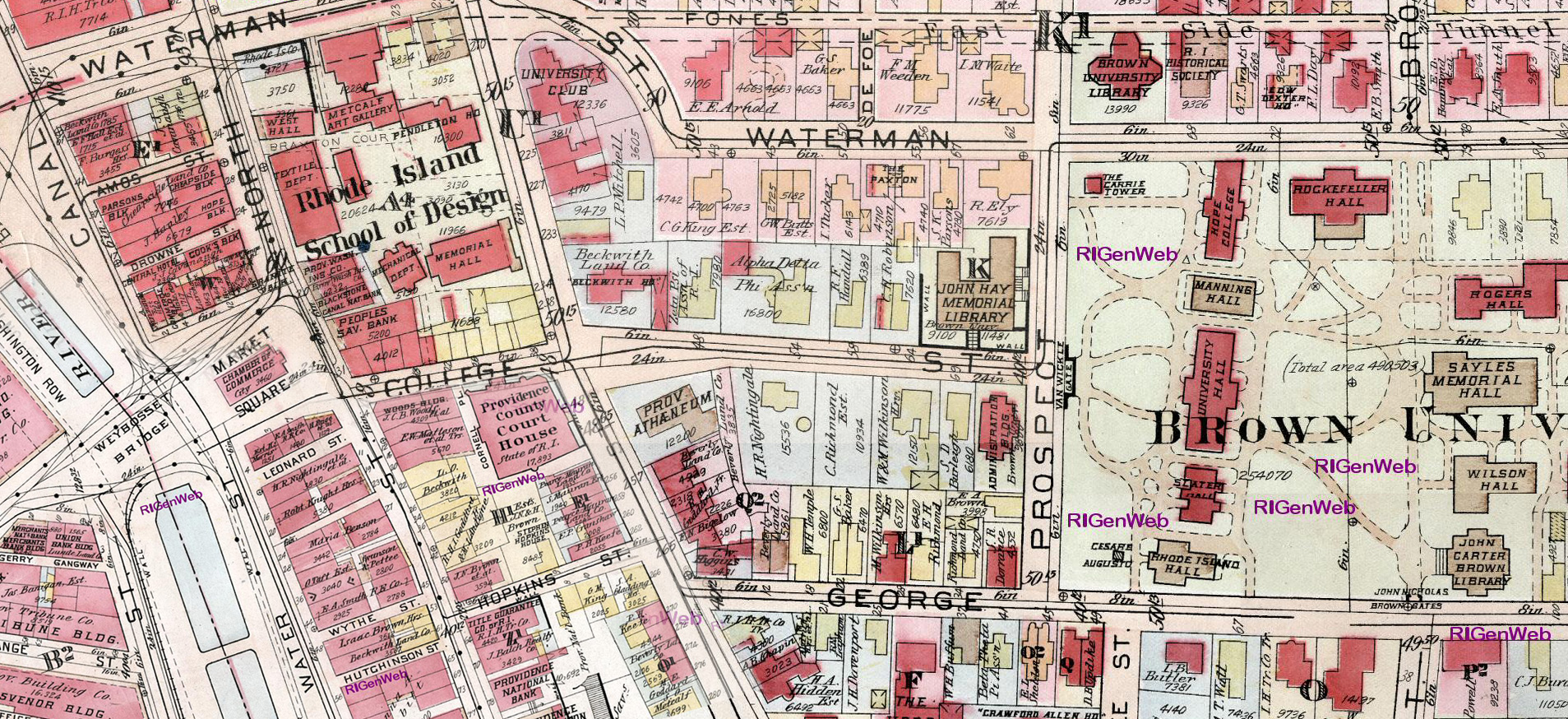
Above: (No.66 detail from Plat Book of the City of Providence Rhode Island, 1918)
Lovecraft’s desk window looked west from the upper floor, and in the other corner he had a seat looking through two paired windows (one facing west and another south). So his desk would have been looking at the back parts of the Alpha Delta Phi (Brunonian chapter) fraternity house at Brown. This appears in “The Haunter of the Dark” as: “Students in the Psi Delta house, whose upper rear windows looked into Blake’s study, noticed the blurred white face…”
Missing picture
Above: Alpha Delta Phi fraternity house. You can see how the curved frontage section corresponds with the map. Lovecraft’s home out of sight directly behind the fraternity house. In the left of his view from his two west windows he would have seen the NE upper windows of the short wing at the back of the fraternity house.
The house has now been moved. Thanks to Andrew Kuchling for the photo (below) of the site of 66 College Street, as it is now. The western view from about 15 ft. above the roof of that little extension of the List Art Building (seen here) would give an approximate indication of the main view from Lovecraft’s study desk. One would need to point the camera so that the Psi Delta house windows are on the far left of the picture being taken and the roof of their little low square building is in the left quarter of the picture.

You can see the location in relation to the road in this picture by Will Hart…

Sadly it now appears there are trees in the way of Lovecraft’s old view, as you can see in this picture by Will Hart …

Remote-controlled hover-drone with HD camera needed, I’d say, to hover just to the left of the top of the central bright green tree in the above photo Alternatively one of the building windows might do it. Keep in mind you’re facing west, so avoid late afternoons and sunsets or you might have difficulties with photographing straight into the sun. A clear bright winter morning might be best, when the leaves are off the trees.
07 Friday Jun 2013
Posted in Historical context, Maps
Very large scale public-domain boundary maps of Providence, scanned from the Plat Book of the City of Providence Rhode Island, 1918. There’s an Overview of sections…

…and hi-res scans of the plates of each section. 160ft to the inch, giving incredible amounts of detail (and also the names of the owner of each house plot) of the streets of Providence.
Presumably surveyed during the First World War, Lovecraft then about age 26 or 27. Compare with the 1891 Survey map to see how the area north of Lovecraft’s home was built up from the 1890s to 1918.
08 Wednesday Aug 2012
Posted in Historical context, Maps
One of the most interesting-sounding fantasy movies of 2012, Wes Anderson’s underage love whimsy Moonrise Kingdom, was partly filmed in Lovecraft’s beloved Lincoln Woods (Lincoln Woods State Park)…
“the Quinsnicket or Lincoln Woods region which I have haunted all my life.” — letter from Lovecraft to Clark Ashton Smith, 1933.
The Cthulhu Prayer Society newsletter #13 (PDF link) has a good account of Lovecraft’s rambles in the Lincoln Woods, in preparation for their own ramble event.
Incidentally, I hadn’t realised that there are a lot of giant glacial boulders to be found in the Park (handy boulder map)…
 Photo: Miles Crawford.
Although sadly some of the boulders appear to have been scrawled on with crude graffiti in modern times. The Park appears to have been started as a reserve in 1907, and a detailed history is the book Lincoln Park remembered: 1894-1987. I’m not sure if the Lovecraft letters appear in this book, or not.
08 Sunday Jul 2012
Posted in Maps, Scholarly works
“I am it, and It is I”: Lovecraft in Providence is an interactive mapping website created by University of Virginia undergraduate Paul Mawye. The site…
“connects short passages from the letters of horror writer H.P. Lovecraft with the geography of […] Rhode Island.”
Thankfully, no Flash is involved. The website instead runs on Neatline, which is a system used to make online projects that display combinations of…
“history, literature, and contemporary space and place”

04 Sunday Mar 2012
Posted in Lovecraftian arts, Maps, Scholarly works
Aajor new research effort into the history and uses of Maps in Science Fiction and Fantasy.
15 Wednesday Feb 2012
Posted in Lovecraftian arts, Maps, Scholarly works
Jason Thompson has completed his giant colour map of Lovecraft’s Dreamlands…

A giant 24 x 36 inch wall-poster version, printing now, can be purchased here.
01 Monday Aug 2011
Posted in Historical context, Lovecraftian arts, Maps
Frank Jacobs surveys the cartographic land octopus…
I suspect it’s those tentacles that explain why the octopus became cartography’s favourite land monster. They turn the CLO into a perfect emblem of evil spreading across a map: its ugly head is the centre of a malevolent intelligence, which is manipulating its obscene appendages to bring death and destruction to its surroundings. This is perfect for demonstrating the geographic reach of an enemy state’s destructive potential. […] The migration of the Kraken to land, somewhere around 1870, can be seen as an escalation, symbolising the hardening of international attitudes.

11 Friday Mar 2011
Posted in Historical context, Lovecraftian arts, Maps, Odd scratchings, Scholarly works
