Pioneering photographers in the Moorlands

I’m pleased to learn that David Cliffe of Leek is doing good work uncovering the photographic history of the town of Leek and the wider Staffordshire Moorlands, and publishing the results as accessible books.

He’s also integrating the knowledge into local mystery novels in his Old Leek Mystery series…

Tragedy strikes when a travelling theatre visits the Staffordshire market town of Leek in Edwardian times. The town also becomes embroiled in suspicion of foreign agents. Local photographer Nathaniel Blake and his teenage daughter Cora turn amateur detective and find themselves in peril.

A better attempt at mapping the line of the Roman Road through Stoke

Having obtained the various OS map coordinates from the North Staffordshire Journal of Field Studies (1967), I can now plot more precisely the line(s) of the ancient Roman Road that ran from Chesterton – Stoke – Longton. The map used is public-domain OS and pre mass-housebuilding.

Updated: fixed dumb WordPress blogging software, which had scaled down the large image automatically. Now links to the full large version!

Two lidar discoveries on the route of the Roman road through Stoke-on-Trent

I’ve found a local item I missed in 2019, an article going by the unpromising name of “Investigation leading to the Scheduling of RR181”, in the Roman Roads Association Newsletter, Summer 2019. Titled differently on the newsletter’s contents-page as “RR181, from realisation to Scheduling”.

Stoke-on-Trent’s Roman road (the ‘Ryknield Street’) from Chester to Derby had, as the article details, been missing knowledge of “its first four miles as far as Langley Common [west of Derby], where no confirmed evidence of the road had ever been identified.” The newletter’s article is mostly about the discovery of this lost Langley Common route and the consequent scheduling.

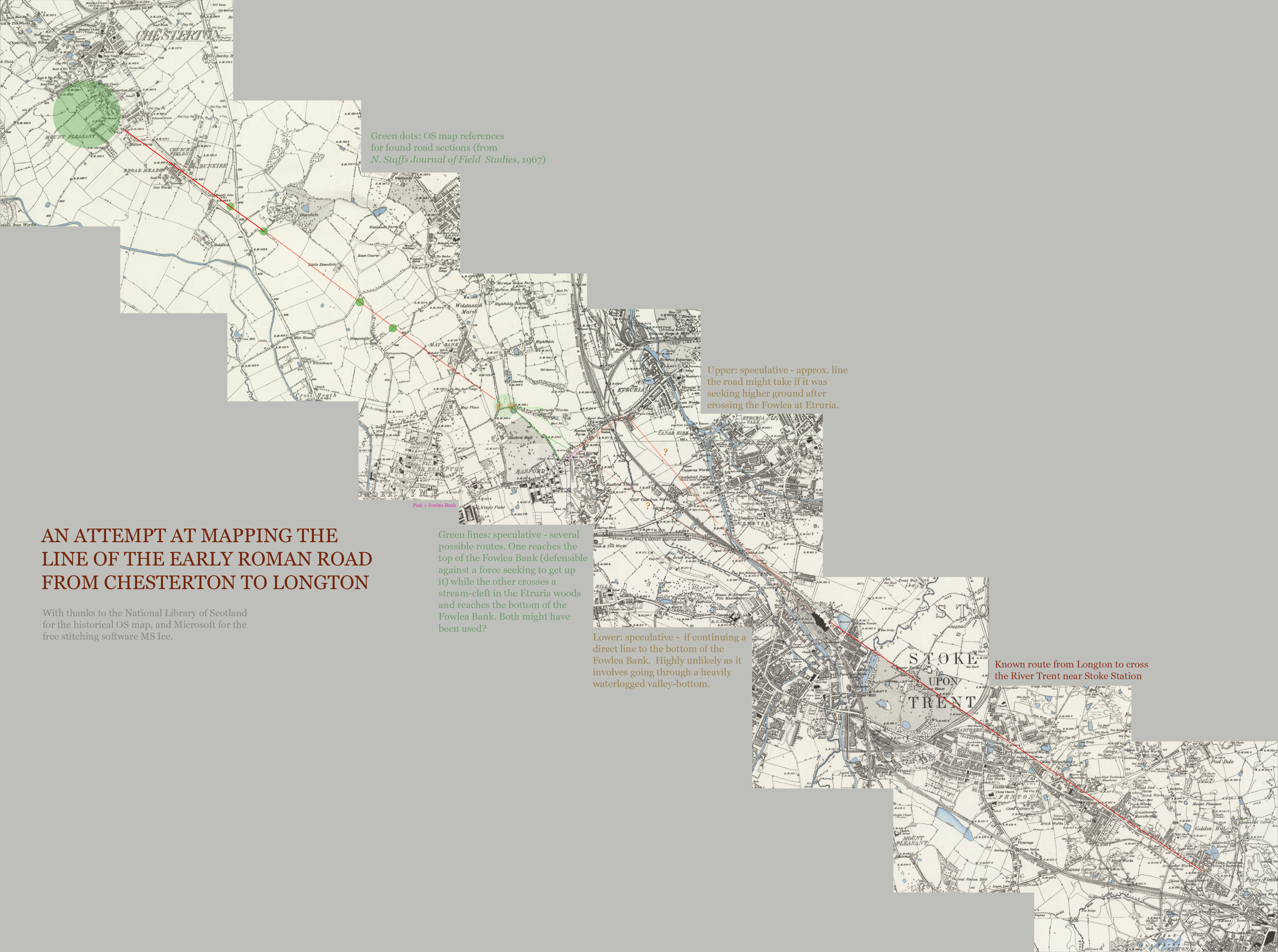
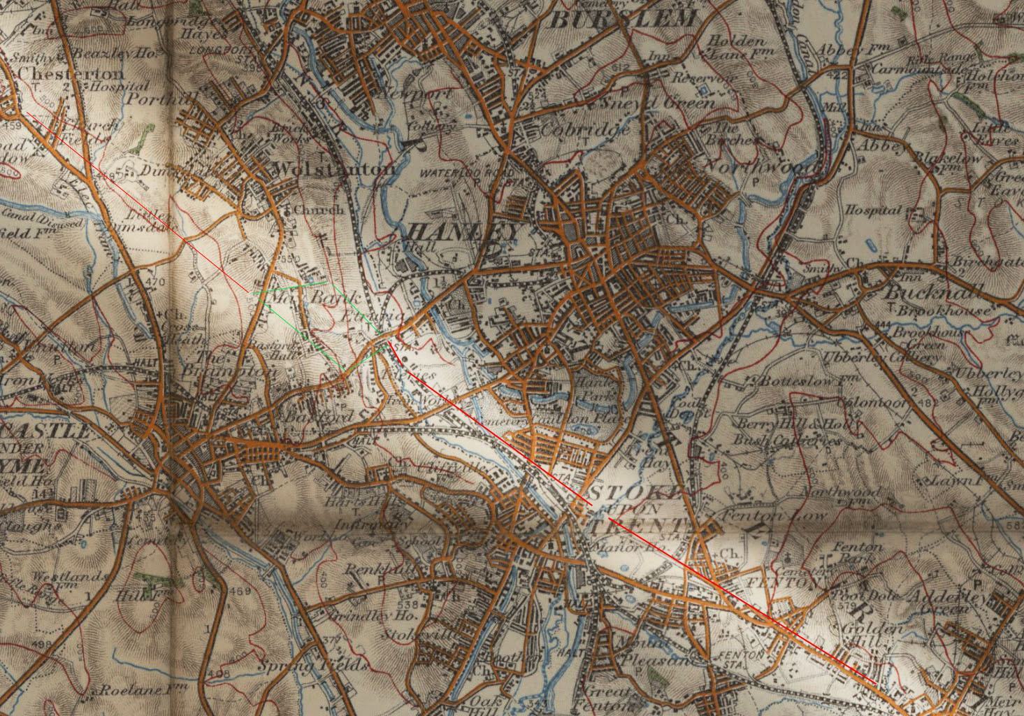
However, page 7 of the same article also usefully details the route back to Stoke-on-Trent and the fort at Chesterton in Newcastle-under-Lyme. This reveals a vital new bit of lidar evidence for Stoke…

Where the Roman line crosses Queensway close to its junction with the A53, lidar [i.e. ground-penetrating radar] reveals a substantial road cutting, now appearing artificially filled. It is conceivable that the Roman road survives well within the cutting.

This is of course only a trace, but it adds good evidence to my suggestions that the Basford Bank was more-or-less the place the road came down off the ridge and crossed the marshy Fowlea valley. The valley would have been just too waterlogged further down, as it approached the Trent. If the road sloped slowly down the valley side from Wolstanton Marsh towards the bottom of the Basford Bank, or if it came down steeply at the old Basford Bank (now the quiet lane behind the modern road) must remain unknown for now. However, the possible need for a deep cutting suggests it came down a steep slope as it approached the Fowlea.

After crossing the Fowlea and the valley-bottom, then much wider and marshier than today, the road must have got up onto somewhat higher ground east of the Fowlea. Before then proceeded on through Cliffe Vale towards its known route past what is now Stoke Station, and then across the Trent (roughly where the University nature reserve is now) and out through Fenton and along part of King Street.

Here is what the article means by the “line”, which I’ve marked approximately here…

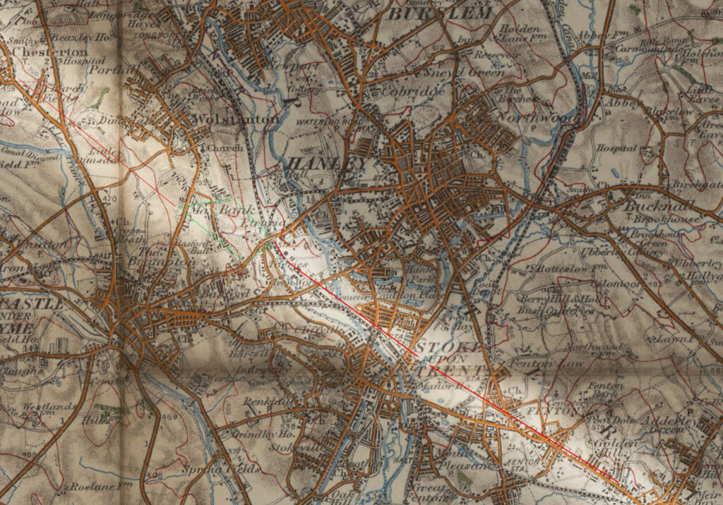
Green indicates the two possible approaches to the Fowlea, either across the top of Etruria Woods and gently down the valley slope, or dropping off the valley side steeply at the old Basford Bank lane.

One might thus whimsically imagine a footsore Roman legion rocking up at the Holy Inadequate pub, had it been there back then, thirsty and in need of reviving drafts of ale! Unfortunately there’s no precise location for the lidar discovery of the buried cutting at the Queensway / A53 junction, and that item in the Roman Roads Association Newsletter article is unreferenced. Possibly it can be seen on recent lidar maps, but I can’t immediately find where those are online. Archiuk.com has a lidar map for Stoke, but it fails to respond and is anyway possibly not up-to-date.


There has also been another key recent lidar development, that I also missed. This discovery was made at the Chesterton end of our Roman road, as detailed at the Roman Roads in Cheshire website…

The route of the [Roman] road is well documented in the north of the county [of Cheshire], but the nearer it got to Chesterton the more its course was lost, with several alternative suggestions. The biggest clue to tracing it south is that the road direction just south of Sandbach appears to be in alignment on the high ground near Bignall Hill / Wedgwood’s Monument. This represents a logical direct alignment, but until lidar [i.e. ground penetrating radar] the evidence was not forthcoming. [But] we can now be confident that the route took a very direct course and went over Bignall Hill / Wedgwood’s Monument, as the lidar evidence is convincing there.

The direct route approached Chesterton fort along the ridge of high ground around [the east side of] Wedgwood’s Monument. The latter would have been a very logical position with excellent view ahead to set out the alignment to Middlewich — assuming it was set out south to north. With the release of Series 2 lidar we now have the [exact] route across Bignall Hill/Wedgwood Monument. [Nearby] Red Street would appear to be a clue [to the presence of an ancient road, due to its name]. It is [however now revealed to be] slightly off line, but must have been named after the [nearby] road.

Or after its purloined stones, perhaps? The routes are very close, and it would have been relatively easy to cart the stones over.

This discovery adds another local node to the route. It came up off the Cheshire Plain and slipped around what is now Wedgwood’s Monument and into North Staffordshire. Which also makes it, in mediaeval times, Sir Gawain’s likely route into North Staffordshire. I had suggested the nearby Red Street for this entry-point in my recent book on Gawain, but now there’s an even more precise mapping. But that’s another story.

So it’s good to learn that the old road isn’t totally forgotten today, and that the lidar boffins still occasionally probe the likely route and make solid discoveries.

Some new local books, recently added to the Internet Archive

Some links to local books, recently added to the Internet Archive:

The 5th North Staffords and the North Midland Territorials (The 46th and 59th Divisions) 1914-1919 (1920).

Notes on Staffordshire Placenames (1902).

Medieval Newcastle-Under-Lyme (1928), by Pape who was the leading local historian of the time.

Memorials of Old Staffordshire (1909), being a book collection of antiquarian essays on various local historical topics, including “Staffordshire Forests”, “Some Local Fairies”, “Old Towers and Spires”, “In Charles Cotton’s Country”, and more.

The Portland Vase booklet (1936), on the history of the making, and the remaking of the vase by Wedgwood.

Story of Wedgwood, 1730-1930 (1930).

Artes Etruriae (1920), being an illustrated booklet giving a tour of the Wedgwood factory in Etruria, North Staffordshire.

Sun Pictures (1859) by Mary Howitt. Being a vivid and lively account of a long summer trek through the Staffordshire Moorlands of England in the late 1850s. 22,000-word travel writing serial, with parts collected into a PDF.

Samuel Parsons 1747 map – North Staffordshire section.

Phillip Lea 1689 map of the country of Staffordshire.

A Uttoxeter Treasure Trove At Your Finger Tips (2025), being “A List Of Books, Publications, Photo Collections On The History And Heritage Of Uttoxeter”.

The Gawain Country (1984) by Ralph W.V. Elliott. Plus several essays published after the book appeared. Sir Gawain and the Green Knight in the Staffordshire Moorlands.

The Oxford Book Of Carols (1928). Has the dream-fantasy hymn/carol “All Bells in Paradise” (with tune) … “this version was recovered in the middle of the nineteenth-century in North Staffordshire”.

DREWEATTS. Old Master, British & European Art. Catalogue 29 May 2025. Auction catalogue with a portrait of the young Thomas Bateman, later maker of Biddulph Grange.

Speculations by T.E. Hulme (1924). Collection of the essays of the North Staffordshire philosopher and early modernist poet, killed in the First World War.

Also of interest, at the National Library of Scotland, Ordnance Survey map of the Staffordshire Potteries & District, O.S. One-Inch 3rd Edition (District) (1913).

New URL for my Spyders blog and ‘Tolkien Gleanings’!

I’ve now moved the Spyders of Burslem blog from the free WordPress blog domain, to a proper hosted WordPress blog install at   https://jurn.link/spyders/ — please update your Web links and RSS feeds.

The new RSS Feed for your feedreader is https://jurn.link/spyders/feed/ for everything posted at the blog, or https://jurn.link/spyders/category/tolkien-gleanings/feed/ if you just want the Tolkien Gleanings newsletter posts.

You can also get the PDF magazine-style omnibus edition of Tolkien Gleanings at Archive.org, with the most recent issue collecting the Gleanings from August to October 2023, with clickable links retained.

The blog links are now a nice green to match the magazine version, turning dark red after you’ve visited them.

Old word: squitch

Popping up on eBay, an old letter of compliant from the days when there were hay-dealers in Shelton, which enshrines the old agricultural word ‘Squitch’. Meaning couch grass.

Squitch. Triticum repens, L. (Lichfield [mid Staffordshire]) — iv. 415. Triticum repens, L., and Agrostis vulgaris, L. Worc[estershire]. —xvii. 38. Also Scutch.” (from Old Country and Farming Words (1880).

Evidently a word known in mid Staffordshire and Worcestershire in the 1870s, and still to be understood in Warrington and Stoke in 1932.

Another Planet

I was forced to go to Hanley today (ugh, even the sunshine couldn’t make it look better), and with a few minutes to spare I decided to pop into Forbidden Planet for the first time. Thinking to see what comics and graphic-novels are being dinged by da kidz these days, and what with my not having set foot in a bricks-and-mortar comics shop in aeons. But… no comics! Not a single one in sight. Looks remarkably like it’s just walls of toys and bags, these days. Oh well, back to digital.

Stoke Comic Swap

Durn. The perils of not being on Facebook any more. I missed hearing about what sounds like a great vintage British comics event right here in Stoke, Wolstanton’s Stoke Comic Swap in June 2025. Let’s hope there’s another one. Down the Tubes has a long report with photos. Apparently the next one is set for Colchester, so that’s no good for me.

Angry Birds

Strange bird behaviour today, in Stoke-on-Trent. In the earliest pre-dawn, a whole lot of crow-flight and verbal calls. And lots of crows in flight, most heading south down the Etruria valley. “They’re up and about unusually early”, I thought. Then, as the light rose, I saw stray seagulls going the opposite way, north up the valley. That’s not unusual just after dawn, as I suspect they sleep down on Trentham Lake or somewhere like that. But this time they were being harassed or shadowed by crows, and were also coming individually rather than in groups as they usually do. Also some which had escaped the crows seemed rather wary, and none were doing their usual ‘leisurely flapping’ northwards (which I assume = ‘scouting for food-litter along the A500 and its feeders’).

“Aha”, I thought. “The crows have cleverly organised an en-masse dawn raid on the seagulls”. Presumably by surprising them mid-air, as they swung into the Etruria Valley heading north. That timing would make sense, since the lack of warm updrafts of air would deny the seagulls some of their soaring capability and manoeuvrability.

Later, I saw a very unusual sight which seemed to confirm my early morning observations. 11am and a dozen seagulls were sitting tight-packed, right in the middle of a medium-sized pond in Etruria. Never seen that before, at any time. Very unusual behaviour, as normally they’d be soaring and looking for food. Sure enough, on getting home I find the crows still making a lot of noise and seemingly ‘patrolling’ up and down the valley. No seagulls about. My guess is that the seagulls on the pond knew what was good for them, and were keeping a low profile in a defensible position. Then, at noon it all went quiet. The crow-clan’s ‘Operation See Off the Seagulls’ was seemingly over.

I wonder if it’s somehow been triggered by the shortage of rain, over the last few weeks? Or perhaps the young crow nestlings are fledged, and about to fly for the first time? I also rather more whimsically wonder if, while all this was going on, the magpies were down on the ground and enjoying scoffing all the Saturday-night food-litter? Amusing to think of them chuckling at the antics of their feathered fellows in the skies above, while scoffing McDonalds. I saw no evidence of that, though.