More newly published evidence on local Roman roads, and also an item of possible relevance to the route that the Gawain-poet knew and had his Sir Gawain take into North Staffordshire. In the form of “The Roman Road in East Cheshire: Unfinished Business”, Journal of the British Archaeological Association, 2025. Sadly this academic journal item is paywalled at a ridiculous £56, but there is at least an abstract…
This short notice considers the possibility that a medieval reference of 1405 provides a missing clue to the existence of a Roman road in east Cheshire. This road, which later marked the western boundary of the Macclesfield Forest, continued southwards via the Staffordshire Way on Congleton Edge to the village of Six Ashes near Wolverhampton, and very probably thence to the Malvern hills and the Severn estuary. Northwards it continued as Staley Street west of the Tame valley on the Lancashire-Yorkshire border, and probably further. It is suggested that in the AD 50s and 60s, the Romans connected the Severn and Humber estuaries by a road to facilitate the swift lateral movement of forces across their front. After the conquest of the Midlands the road had no enduring military value but may subsequently have been exploited as a trade route.
“The Staffordshire Way” here is presumably a reference to the modern long-distance footpath. On “the western boundary” of the forest, the History of Macclesfield states…
The Forest of Macclesfield […] western boundary was approximately the present London Road from the Rising Sun Inn to Prestbury, from thence along the Macclesfield township boundary to Gawsworth, where it avoided the precincts of the church and continued south to the Dane.
But it’s then a huge jump by the new article’s author between the Congleton Edge and all the way down to Wolverhampton. Actually not Wolverhampton at all, except by modern postcode. It turns out that Six Ashes is far west of Dudley and near Bridgenorth.
So it’s an interesting claim that touches on local topography. But the paywall means one can’t find out more. One wonders what evidence the author has for claiming the long Congleton Edge -> Six Ashes run, if any? Since the abstract suggests the (new?) “1405” evidence relates only to “a Roman road in east Cheshire”, and not down through Staffordshire. If it also referenced Staffordshire, then surely the abstract would say so?
And if there was once an early road along the Congleton Edge, then where would it go after that?
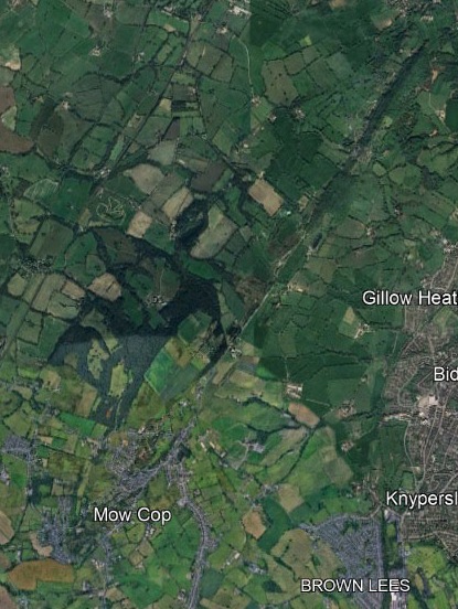
Roman roads were largely straight and the straight Congleton Edge line points directly at Mow Cop. Which was quarrying some of the best millstones in Europe, and thus would logically need sturdy roads to haul the finished millstones out.
One then has to suppose the hypothetical road would go on from Mow Cop, to somewhere around Talke and hook up with our known early Roman road going to Chesterton… and then to what would become Stoke. That said, some of our Roman roads do appear to go nowhere/somewhere and then stop. There’s one which was unearthed for a long length in 1961 at Hanchurch during motorway work, and seemed to go nowhere. Also the Roman road from Buxton towards Leek, which I would guess didn’t need to go further… because it only needed to access the sheep country of the Moorlands rivers via the trackway along the Morridge edge?